
Short hikes and walks
Yoho National Park
In Yoho National Park, you do not have to go very far from your car to find breathtaking views. Whether you are new to hiking or short on time, there are short hikes and interpretive walks to enjoy. Choose the trail that is right for you. Find maps, trail descriptions and safety information.
For maps, detailed route finding and trail descriptions, visit the Yoho Visitor Centre or purchase a hiking guide book and topographical map. There is limited cell service in Yoho National Park.
Hiking in Yoho National Park
Short hikes and walks in Yoho National Park
| Trail | Distance (return) | Time (return) | Elevation gain |
|---|---|---|---|
 Wapta Falls Wapta Falls |
4.6 km | 1.5 hours | 30 m |
| Emerald Lake |
5.2 km | 2 hours | minimal |
| Hamilton Falls |
1.6 km | 30 minutes | minimal |
| Centennial |
2.5 km | 45 minutes | minimal |
| Kicking Horse to Amiskwi |
3.6 km | 1.5 hours | 50 m |
| Great Divide |
6 km | 2 hours | minimal |
| Ross Lake |
6.4 km | 2 hours | 100 m |
Thanks to an ongoing collaboration between Parks Canada and Google, you can now explore some Yoho National Park highlights using Street View for Google Maps.
Trail descriptions
Wapta Falls
Wapta Falls
Length: 4.6 km
Hiking time: 1.5 hours
Elevation: 30 m
Trailhead: Wapta Falls parking area, 26 km west of Field, B.C. and 32 km east of Golden, B.C. on the south side of the Trans-Canada Highway. Note: The trailhead is not marked for westbound traffic as there is no left turn lane here. Continue west for another 5.5 km to the park west boundary, turn right at the Beaverfoot exit and come back on highway 1 east. (map)
Habitat: With the ecologically important Leanchoil marsh nearby, watch for waterbirds, beavers and wolf tracks.
Description: A lush, forested walk to the base of an impressive 30 m waterfall; the largest waterfall on the Kicking Horse River.
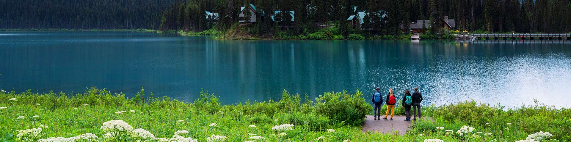
Emerald Lake
Emerald Lake
Length: 5.2 km
Hiking time: 2 hours
Elevation: minimal
Trailhead: Emerald Lake parking area, 10 km west of Field, B.C. via the Trans-Canada Highway and Emerald Lake Road. (map)
Habitat: A typical, sunny Rocky Mountain forest on the west side of the lake, and a more moist Columbian forest with cedar and hemlock on the east side.
Description: A gentle, lakeshore trail surrounded by mountain and glacier views. Includes a level, gravel path from the parking area to the bridge at the back of the lake.
Google Street View: Emerald Lake
Hamilton Falls
Hamilton Falls
Length: 1.6 km
Hiking time: 30 minutes
Elevation: minimal
Trailhead: Emerald Lake parking lot entrance, 10 km west of Field, B.C. via the Trans-Canada Highway and Emerald Lake Road. (map)
Habitat: A lush, green forest typical of Yoho. Watch for hydro-power artifacts from an earlier age.
Description: A pleasant stroll to a delicate cascade.
Centennial
Centennial
Length: 2.5 km
Hiking time: 45 minutes
Elevation: minimal
Trailhead: Start at the bridge at the entrance to Kicking Horse Campground, 4 km east of Field, B.C. on the Yoho Valley Road. (map)
Habitat: Part of an important wildlife corridor. Watch for mountain goats above.
Description: A shaded trail along the Kicking Horse River that is known for wildflowers.
Kicking Horse to Amiskwi
Kicking Horse to Amiskwi
Length: 3.6 km
Hiking time: 1.5 hours
Elevation: 50 m
Trailhead: Natural Bridge parking area, 4 km west of Field, B.C. on Emerald Lake Road. (map)
Habitat: Mineral lick in the area. Watch for wildlife here at the confluence of three important valleys.
Description: Walk or cycle a forested road to a picnic site at the confluence of three rivers.
Great Divide
Great Divide
Length: 6 km
Hiking time: 2 hours
Elevation: minimal
Trailhead: Lake O'Hara parking lot on the south side of the Trans-Canada Highway, 13 km east of Field, B.C. (map)
Habitat: A key pinchpoint for wildlife movement. Watch for bears.
Description: Walk or cycle on a closed, paved road to the historic archway marking the location of the Continental Divide.
Ross Lake
Ross Lake
Length: 6.4 km
Hiking time: 2 hours
Elevation: 100 m
Trailhead: Lake O'Hara parking lot on the south side of the Trans-Canada Highway, 13 km east of Field, B.C. (map)
Habitat: Typical Yoho forest, with a shallow creek crossing and marshy areas navigable by boardwalk.
Description: Start on an abandoned road and continue on a forested trail to a lake set at the headwall of Narao Peak.
Related links
- Date modified :