
Cycling
Gros Morne National Park
There are no specifically designed bike trails in Gros Morne, but mountain bikes are permitted to use Stuckless Pond trail Western Brook Pond Trail the Old Mail Road as well as the 11 km of looped ski trails near the Visitor Centre. With its great views of Gros Morne and the Long Range Mountains, the Eastern Arm Pond cabin access road across the highway from the Visitor Centre is a favorite of local riders. North and south of the park, there are kilometers of woods roads.
Gros Morne National Park Biking Trail Descriptions
Old Mail Road
Distance: 2km return Terrain/Elevation: Flat/0-5m Difficulty: Easy (Beginners and Families)
An easy 2km-return ride in the shelter of forests and sand dunes, appropriate for any skill level. Trail leaves from the Shallow Bay day use area, and follows the old winter mail road along the edge of the campground and north to Slants River. Wonderful dappled light and access to sandy beach. This is a shared-use trail. Please ride in control and yield to other trail users. Located 3 km north of the community of Cow Head. This trail starts at the Shallow Bay day-use area.
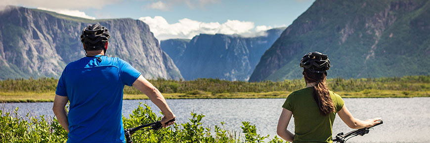
Western Brook Pond
Distance: 6km return Terrain/Elevation: Flat/10-35m Difficulty: Easy (Beginners and Families)
Follow the trail to the shores of Western Brook Pond and its impressive backdrop of spectacular cliffs and the Long Range Mountains. Along the way you’ll cross the bogs and forested ridges of the parks’ coastal lowlands. Trail is primarily a wide gravel path with some boardwalk, appropriate for any skill level.
This is a popular shared-use trail. Please ride in control and be aware of other trail users.
The trail leads to the departure point of the Western Brook Pond boat tour. Boat tours run daily from mid-May to mid-October, weather permitting.
Located 27 km north of Rocky Harbour on route 430.
Stuckless Pond
Distance: 9.5 km return Terrain/Elevation: Moderate/0-125m Difficulty: Moderate (For Intermediate Riders)
Follow the old logging road through old growth forest to skirt the shores of secluded Stuckless Pond. The trail crosses the Lomond River bridge, then climbs steadily before it plateaus and circles the sheltered pond. Riding conditions range from hard-packed surface to rough rocky areas and narrow winding trails through forests.
This is a shared use trail. Expect to encounter other trail users. Please ride in control and be ready to stop at any time.
Located 16km from Wiltondale, west on route 431. Trail begins from the Lomond River / Stuckless Pond Trail parking lot.
- Date modified :